
Upper Austria, Austria
Hinterstoder
No ratings yet
Up to 2000m
40 km of slopes
About Hinterstoder
Major ski area in the Totes Gebirge with challenging terrain and excellent off-piste opportunities
Plan your stay in Hinterstoder
Compare hotels, chalets and apartments in and around Hinterstoder — book instantly with free cancellation on most rates.
No villages available
Ski Area Map
Ultra High Resolution
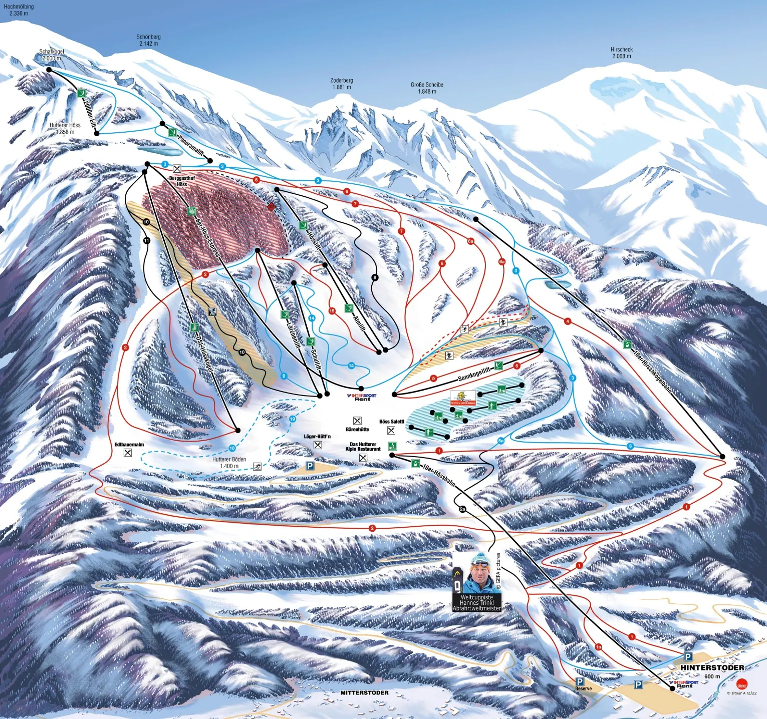
Official ultra-high resolution ski area map showing all slopes, lifts, villages, and mountain facilities. Features detailed terrain information with difficulty levels and connection points between villages.
🎿 40km of Slopes
🚠 13 Lifts & Gondolas
🏔️ 600m - 2000m
⛷️ 12 Easy • 18 Medium • 10 Difficult
❄️ 85% Snow Making
🍽️ Mountain Restaurants
🎯 Terrain Parks
Current weather
Weather Station • 589m
14°C
Valley • 600m
5°C
Mountain • 2000m
5 km/h
Clear
Season & slopes
Key facts at a glance — open the tab for live slopes and lifts.
15th of December – 8th of April
Season
40 km
Ski Area
13
Total Lifts
1400m
Vertical Drop
85%
Snow Making
Resort Features & Highlights
Skiing & Snowboarding
Beginner Friendly
Family Resort
Expert Terrain
Snowpark Available
Resort Amenities
Mountain Restaurants
Parking Available
Child Care Services
Night Skiing
Live Resort Status
Resort Status:
Closed
Ski Area Status:
Closed
Last Update:12:00 PM
Snow Conditions
Valley Snow Depth
-
Mountain Snow Depth
-
Season Information
Season Start:15th of December
Season End:8th of April
Peak Season:Dec 20 - Jan 8
Operating Hours:8:30 - 16:00
Technical Details
Location & Contact
Address:
Upper Austria, Austria
Coordinates:
47.69957°N, 14.15468°E
Similar ski areas
Discover other ski areas that match this resort.


