
High Tatras, Slovakia
Tatranská Lomnica
No ratings yet
Up to 2190m
11 km of slopes
About Tatranská Lomnica
Historic ski area in the High Tatras with cable car access to Skalnaté pleso.
Plan your stay in Tatranská Lomnica
Compare hotels, chalets and apartments in and around Tatranská Lomnica — book instantly with free cancellation on most rates.
No villages available
Ski Area Map
Ultra High Resolution
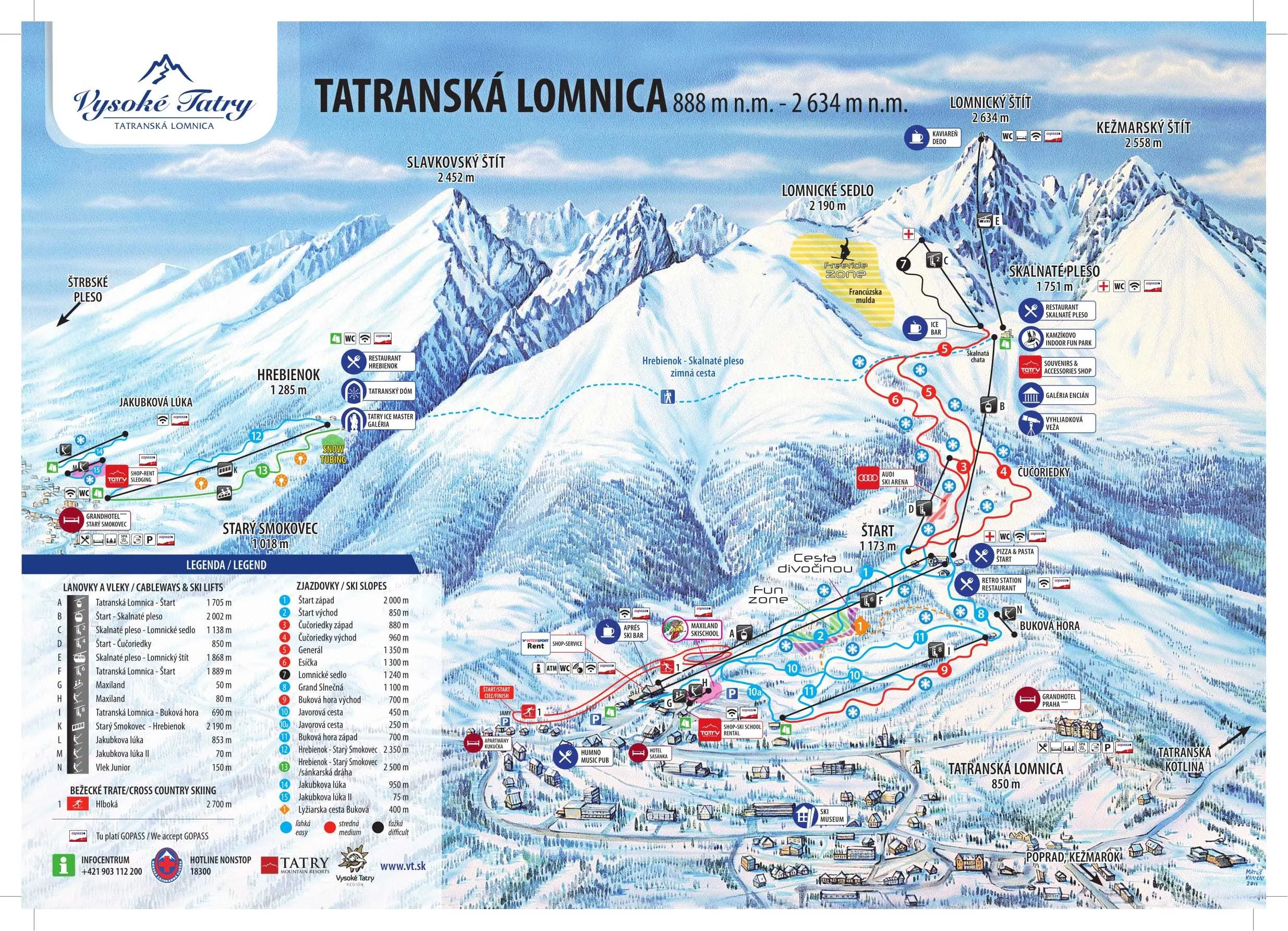
Official ultra-high resolution ski area map showing all slopes, lifts, villages, and mountain facilities. Features detailed terrain information with difficulty levels and connection points between villages.
🎿 11km of Slopes
🚠 9 Lifts & Gondolas
🏔️ 888m - 2190m
⛷️ 5 Easy • 5 Medium • 1 Difficult
🍽️ Mountain Restaurants
🎯 Terrain Parks
Current weather
Weather Station • 852m
15°C
Valley • 888m
7°C
Mountain • 2190m
16 km/h
Clear
Season & slopes
Key facts at a glance — open the tab for live slopes and lifts.
13th of December – 12th of April
Season
11 km
Ski Area
9
Total Lifts
1302m
Vertical Drop
N/A
Snow Making
Resort Features & Highlights
Skiing & Snowboarding
Beginner Friendly
Family Resort
Expert Terrain
Snowpark Available
Resort Amenities
Mountain Restaurants
Parking Available
Child Care Services
Night Skiing
Live Resort Status
No live status data available
Snow Conditions
Valley Snow Depth
-
Mountain Snow Depth
-
Season Information
Season Start:13th of December
Season End:12th of April
Peak Season:Dec 20 - Jan 8
Operating Hours:8:30 - 16:00
Technical Details
Location & Contact
Address:
High Tatras, Slovakia
Coordinates:
49.16616°N, 20.28128°E
Similar ski areas
Discover other ski areas that match this resort.


